During lockdown, the Trust continued to control Giant Hogweed as it is a public health risk and we feared that if left to go to seed we would be faced with an unmanageable problem in 2021.
Normally the Trust controls the plants at the top of the river between Currie (location of the highest plant) and Slateford. As we have this area under control we are in a unique position to be able to carry out research into the alternatives to using Glyphosate herbicide to control Giant Hogweed with Edinburgh Napier University Life Science department. We are currently in year 3 of a 5-year project.
Giant Hogweed on the rest of the river (Slateford – Leith) is normally managed by the CEC, but they were unable to do this due to Covid, so it was agreed by the Trust and the Council that Charlotte accompanied by one volunteer (Tony, Ian or Joe ) would manage all the Giant Hogweed plants on the river during lockdown. This was only possible as group activities were suspended by the Trust due to the pandemic.
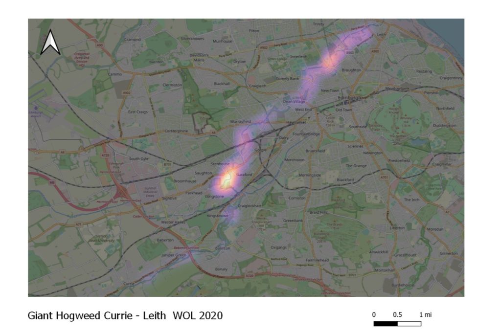
As Charlotte was used to mapping plants with a handheld GPS’s for the research project, she decided to continue mapping. The overview of the distribution of plants would be key information, never before achieved on the WOL.
It took Charlotte, Joe, Tony and Ian 18 days to survey and wade from Currie – Leith. They recorded and treated 2350 Giant Hogweed plants. Every plant was mapped. With the help of Bryn MaCaulay, a volunteer who has recently graduated from Edinburgh University with an MSc in GIS, we have produced a Heat map with the data. The map reveals the distribution of Giant Hogweed along the whole length of the river. Area’s that have more Giant Hogweed, compared to the rest of the river, show up as pink or white-hot. The map reveals that the upper reaches, which are being used as research into alternatives to Glyphosate are not as much as an issue as downstream. A major hotspot for the plant is Longstone – Gorgie, starting where the Murryburn joins the WOL. Other areas that have larger amounts of the plant are Murryfield and Warriston.

This map has been forwarded to the Council who are now able to resume their normal management of the plant. We are hoping that the Murryburn will receive a bit more attention as it looks like plants from this burn are spreading into the WOL and creating problems all the way to Leith.
We cannot thank Tony Gray, Ian Combe, Joe Hilton and Bryn MaCaulay enough for all their help with this during a difficult time. The information gathered has revealed some very valuable information that will really help with the long term management of Giant Hogweed on the WOL.


